
Finding Who Lives on a Lehi Street
A street-by-street search starts with an address and ends with a set of qualified clues. Ownership is the clearest public connection because the Assessor and Recorder tie names to parcels and instruments. Residency is less certain. A voter address is regulated, a directory is a time slice, and a mailing address can point somewhere other than the property.
- Enter the number, direction, street name, type, and Lehi location in the Utah County Assessor search.
- Copy the returned serial and open the same parcel in the Utah County Parcel Map.
- Record situs and mailing addresses, subdivision or lot details, and the date you searched.
- Follow the Recorder entry, year, KOI or instrument, grantor, grantee, and linked document path.
- Use permitted voter data or a historical directory only to answer the narrower question it supports.
This order matters. The serial gives the street directory a steadier key than a typed address, especially in a fast-growing part of Lehi.
Normalize a Lehi Street Address
The Assessor instruction separates address number, direction, street, street type, and city or location. Street types shown in the research include Street, Drive, Circle, Way, Lane, Avenue, Boulevard, Court, Parkway, Place, and Terrace. Test the parts separately when a full-string search fails. Use Lehi as the location, then use a ZIP as a check rather than the main key.
Older material may use a locality name rather than modern Lehi. Historical sources mention Sulphur Springs, Dry Creek, and Evansville. An old street number can also require a plat, Sanborn map, or city confirmation. The reviewed sources did not establish a single citywide renumbering date, so do not invent a conversion. Note the original wording and the modern match as separate facts.
Why Lehi Parcel Records Start With a Serial
Utah County’s Recorder warns that not every parcel has an address, cities may fail to update the Assessor, and apartment or plat addresses can create confusion. The county sample property card uses serial 38:347:0109 and links to owner names, value history, tax history, location, photos, documents, and aerial imagery. It also shows acreage, a subdivision description, and a last document. That level of detail is why the serial should carry the search from map to deed.
Address vocabulary. Parcel means the mapped property unit. Situs means the physical property location. Mailing means the destination for owner notices. A plat describes a mapped subdivision. A criss-cross directory is an older address-order directory, not a modern household list.
Do not treat the sample’s matching situs and mailing address as a rule. A corporation, trust, estate, lender, or developer can direct mail elsewhere. Save both fields whenever the property card supplies them.
Browse Lehi Parcel Records in GIS
The Utah County Parcel Map has a Search Panel, Map Layer, Basemap, Historic Parcel, Map Tools, Print, and Support controls. Address or place autocomplete, serial number, owner name, and PLSS township, range, and section searches are available. A street directory walk uses the address to locate the first parcel, then pans along the road and opens each neighboring card.
Serials can be entered as 123456789, 12:345:6789, 12 345 6789, or 12-345-6789, and several serials can be comma-separated. Owner-name searches can be slow. The historic date control shows the parcel system’s selected date view, not necessarily a deed recording date. Use Print when a map snapshot belongs in a source log.
For a visual reference, the Utah County GIS program explains parcel maps, polling maps, downloads, and other county layers.
This GIS image shows the county resource route. It supports parcel discovery, but the map itself is not evidence of who occupies a building.
Lehi Records Searchable by Street
Several record sets can be keyed to an address, but each has a different person field and time range. The street directory is useful when those layers are kept distinct and joined by serial, entry, date, or source page.
| Record Set | Keeper | What It Shows | Access |
|---|---|---|---|
| Assessor / Land Records | Utah County | Owner, situs, mailing, value, tax, serial | Online search, counter fallback |
| Parcel Map | Utah County GIS | Boundaries, owner context, historic parcel view | Free viewer and map tools |
| Recorder | Utah County Recorder | Entry/year, grantor, grantee, KOI, deed route | Index, image route, Provo office |
| Voter data | County Clerk / Vote Utah | Permitted name, address, year, party, vote fields | Own status or lawful request |
| Permits | Lehi City | Site address, permit, subdivision or lot, inspection status | City portal or department request |
| Newspapers and directories | Historical Society / libraries | Past names, addresses, notices, household clues | Catalog, scans, in-person help |
A street name discovers candidates, the parcel serial joins property systems, and the deed entry supplies dates. The full historical collection route belongs on the Lehi city directories page, where the older shelf is explained without turning it into a current roll.
Use Lehi Assessor Records Precisely
The real-property form supports more than one search path. If the street is known, use the address parts. If the number is uncertain, try an owner name or serial. The record-scope choice can show All Records or Current Records Only, which changes how a result should be read.
| Address number | Street number, optional in the captured form. |
|---|---|
| Direction | Separate N, E, S, or W direction control. |
| Street type | Type selector such as Avenue, Boulevard, Court, Drive, Lane, Place, Parkway, Street, Terrace, Way, or Circle. |
| Name | Owner name route; test spelling and partial behavior live. |
| Serial number | County parcel identifier. |
| Scope | All Records or Current Records Only. |
The Assessor handles market value, real and personal property, and exemptions. It does not process name or address updates, collect taxes, or establish occupancy. The Treasurer is the tax-collection office.
Build a Deed Chain Along the Street
Open the current parcel card, capture its serial, and use Land Records document and serial-history routes. The Recorder sample entry displays serial number, entry number and year, KOI or instrument code, grantor, grantee, and sometimes multiple parcels or parties in one entry. Follow the current grantor backward through prior entries, keeping the instrument and date with each name.
The Recorder does not perform a title search or give legal advice. Online deed access reaches roughly the 1980s according to the local-history guidance; older abstract books, plats, images, mail, or a Provo counter request may be needed. Deed copies are listed at $1 per page in the Recorder FAQ, but check the current fee schedule for other products.
The Utah County sample grantor-grantee entry shows how a street record can be followed by serial and entry.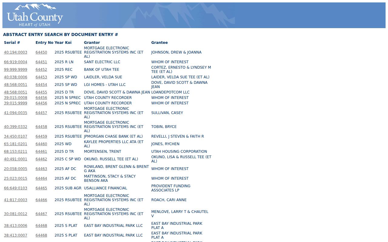
The entry image is a model for a source log. It does not make the indexed party a current resident.
Put Dates on a Lehi Building Record
Lehi Building and Inspections uses a permit and inspection route tied to permit number, site address, or subdivision and lot. Inspection scheduling asks for 24-hour notice. The public research did not confirm every submittal-portal field or every plan image, so describe a permit as a city record lead rather than promise a complete online file. Fire permits and fire-report copies have their own department route and published fees.
After the parcel is identified, validate its ZIP. USPS made 84048 effective July 1, 2025 for northern Lehi, while the rest of Lehi continued with 84043 through the Lehi Post Office. UGRC ZIP polygons are approximate delivery areas, not city limits. This matters when older records show 84043 or when a postal city and parcel boundary seem different.
Read Lehi’s Historic Street Records Carefully
Lehi’s June 1854 fort survey laid out 16 city blocks, each 330 feet square, with streets 99 feet wide. That grid is useful context for old plats, Sanborn maps, and directory addresses, but it does not guarantee that a historic number matches a modern number. The Historical Society’s Sanborn maps from 1890, 1898, and 1907 can show structure, use, and street context.
When a street directory search returns nothing, try the owner or serial, inspect the map, ask the city about address assignment, and use a plat or newspaper. Preserve the historical locality name, street spelling, and year. A documented gap is better than a guessed conversion.
What a Lehi Street Directory Cannot Show
Public property data does not provide a complete list of household members or renters. DMV address records are protected under the federal driver-privacy rules, utility customer lists are not public, and an association page may publish only its board. A voter file has legal access limits and protected or at-risk people may be omitted. A historical criss-cross result is a past snapshot, not a current address.
Lawful use. Use street and address records for a defined personal, family-history, civic, or property purpose. Utah’s stalking law covers repeated monitoring, approaching a residence or neighbors, communicating, photographing, or disseminating information used to intimidate. Never use a street directory to stalk, harass, threaten, or harm anyone.
Keep a source log with the address as searched, serial, record number, date, URL, image or page, and uncertainty. That practice makes a Lehi by-address result auditable while respecting what the records do not say.
For a long street, work in a repeatable order. Save one parcel card, then the next, and do not mix results from different search dates without labeling them. Record the direction and street type as the portal returned them. If the map offers a historic parcel view, label that date as a GIS system view rather than a deed date.
Older streets may need more than a current address. The Historical Society’s Sanborn maps can show how a building and street fit together in 1890, 1898, or 1907. The Society’s newspapers and FamilySearch catalog can supply a name or date. This is where the modern street directory hands off to the historical shelf, rather than forcing a current portal to answer an old question.
For a missing online record, the fallback chain is concrete: try owner name, serial, map, Recorder entry or book route, then ask the city or county custodian. Utah County offices in Provo handle the main land-record trail. Lehi City handles its permits and city records. A request should identify the office and existing record sought, because GRAMA does not require staff to create a new research answer.